
RELATED: Cottrel: DNA test a golden ticket for family history
As I watched the traffic speeding up and down Ohio 4 between Enon and Springfield, I wondered how many of those motoring past knew that they were driving through a Revolutionary War Battlefield, the site of the largest Revolutionary War battle fought west of the Allegheny Mountains.
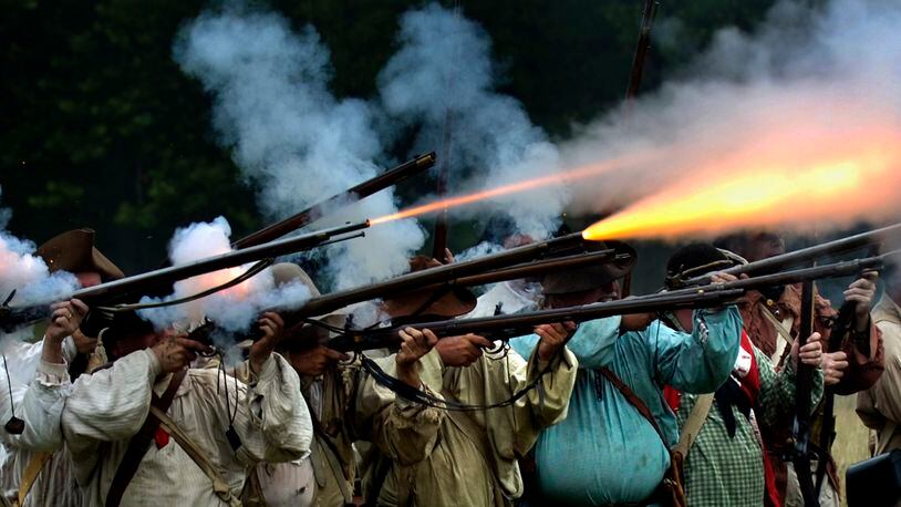
Up on the hill there were speeches, a wreath lying, and cannon and musket salutes as those in attendance remembered the events of Aug. 8, 1780, 237 years ago.
In 1780 the flat lands there were full of corn fields; 800 acres of corn by some accounts. These cornfields were tasseled and already had formed ears that some could eat. Mixed in with the corn were bean plants that climbed some stalks, and squash plants that shaded the roots and kept weeds from taking over. The soil was rich and fruitful.
The Shawnee village known as Peckuwe stood along the area below the rise in land. Peckuwe was mostly log cabins with the traditional wigwams mixed in. The Shawnee had adapted quickly to the construction methods demonstrated by the French fur traders and the English settlers. Mingo, Miami, Ottawa, Lenape and Wyandot families also lived in this village. Most wore linen shirts and wool they had purchased with beaver pelts, and buckskins.
DETAILS: Cottrel: Unknown Clark County treasure now open
But Peckuwe had one thing that made it different from other villages - it had a wooden stockade. Built by their allies the British, the triangular fort stood on a rise overlooking the village and cornfields, and higher than any flood waters could ever reach. A second village, Kispoko, was not far away nestled among the low hills to the east along the river.
The panorama of the village would have been spectacular. This was a huge inhabited area, and its influence on the region was great.
But there was a problem. From this fort the British soldiers from Detroit and allied warriors launched raids on the settlements in Kentucky.
After two particularly awful massacres in the summer of 1780, the Kentuckians banded together to strike back. Led by Colonel George Rogers Clark, 1,000 soldiers and militia determined to hurt the British and their allies enough that the attacks on the Kentucky settlers would stop. Col. Clark was already a Revolutionary War hero at the age of 28.
READ MORE: Cottrel: Historic flood planning key for Dayton, Springfield region
Chief Blackhoof had the Indian families evacuated well before the American forces arrived, but around 300 warriors faced 1,000 Americans. There were no British in the battle, because they were back home in Detroit at the time.
The battle lasted all afternoon. The Americans with their cannon won the day, but not without significant casualties on both sides. The village and fort were burned. The corn crops were destroyed, and the native peoples moved north to other villages of their people. Some would eventually settle along the Miami River and give their new town the same name as the one destroyed. We call it Piqua today.
Settlers would arrive at the site of the old Peckuwe less than 20 years later and a little town called New Boston was built on the site. Springfield would eventually overshadow New Boston and the battlefield would become farmland.
MORE COVERAGE: Former Clark County school finds new use as farm market
That wide flat area that drivers see to the north of the highway was the contested ground. Shawnee warriors with their allies and American soldiers and militia fought and bled into that soil. Some are buried out there in unmarked graves. The ash from the burned cabins and fort have mixed in with the soil too. It is hallowed ground. A tall stone monument looks over the site from the hill.
A battle that shaped the future of this country was fought there. Both sides were fighting for their homeland and families. This is why we are named Clark County.
So when you drive on that part of Ohio 4, turn off the music or talk radio for a minute and think of the history you are driving through. Your remembering also honors those who fought here.
About the Author