
Dayton is in the process of getting a riverfront master plan of its own.
Dayton’s river banks already have welcomed some new apartment buildings, enhanced access points and outdoor restaurant space. Investments in downtown and the riverfront have exceeded $1 billion since 2010, officials have said.
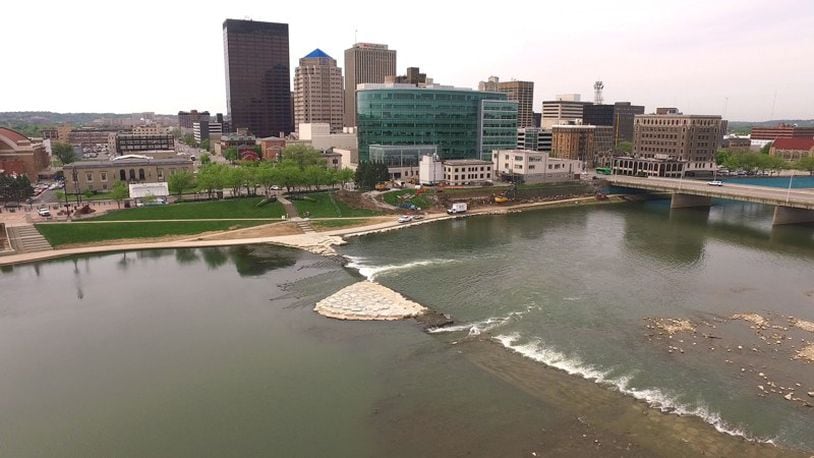
EARLIER: A traveling beer garden, new pedestrian bridges and other ideas for Dayton’s riverfront
But there’s opportunities for much more, such as new housing, parks, connections between amenities and recreational and retail destinations, including restaurants and a beer garden, officials said.
The Dayton Riverfront Plan has some big and fresh ideas for the 12 miles of waterways in the city of Dayton.
A synopsis of the final draft of the long-term master plan was presented to the Dayton City Plan Board this week.
Dayton’s rivers have always been a hard dividing line in Dayton, slicing up sections of the community and isolating some neighborhoods , city officials said.
RELATED: 20-year plan tries to make Dayton’s rivers more accessible, profitable
But the riverfront master plan under development calls for new investments and amenities that unite opposite sides of the city’s waterways, such as pedestrian bridges, river crossings, trail enhancements and extensions and new ramps.
In downtown, the plan highlights areas that are strong candidates for new housing or other development, including Deeds Park and land east of the McPherson Town historic neighborhood.
The plan seeks to improve access and remove barriers to the river, which have included parts of the current levee system and some roadways and infrastructure projects, said Jon White, city of Dayton planner.
The realignment of Interstate 75 opened up new riverfront space on west bank of downtown, but the project also has created barriers blocking direct and easy access to the waterway, White said.
“Quite frankly, we think they did a poor job on some of the on and off ramps,” White said.
The plan suggests adding pedestrian bridges around downtown, including one to connect Sunrise MetroPark with a new “Sunset” park across the river.
Right now, there’s an existing pedestrian bridge over the Mad River that connects Deeds Point MetroPark to the Webster Station area.
Plan backers say they would like to better link RiverScape with Rivers Edge Park, which is located just west of North Main Street.
White said one long-term proposal is to move Dayton’s fire department headquarters from North Main Street and Monument Avenue so the building can be adaptively reused for other purposes. That could help extend RiverScape west to create a more continuous riverfront, he said.
Infrastructure upgrades could aid cyclists and pedestrians. Planners said they would like to see the Dayton Art Institute’s front lawn extended.
About 26 Dayton neighborhoods touch the waterways, and the master plan makes a variety of recommendations for all sections of the river corridor.
For instance, one proposal is to close down North Bend Boulevard to auto traffic on the west side of Kettering Field to create a promenade that provides a better pedestrian experience, White said.
Other proposals include putting Riverside Drive on a road diet and removing part of the dam by Island MetroPark to create a passage for paddlers, he said.
The consultants who worked on the plan recommend improving the connections between the east and west sides of the Stillwater River along Deweese Parkway, including a proposed bridge at Drill Avenue and other pedestrian crossings, said Carrie Scarff, Five Rivers MetroParks chief of planning and projects.
The plan seeks to coordinate investments in the nine main parks along the river corridor study area to create a regional destination and guide investments along the rivers for the next 20 years, Scarff said.
“Over the course of the next 20 years, how can we take that next giant step?” she said.
The Mad River, which stretches east to Eastwood MetroPark, has some of the most natural landscape.
But part of the river abuts Webster Station, which is one of the hottest and fastest growing parts of the city of Dayton and is home to Tech Town.
A project called Webster Station Landing recently was allocated $200,000 from the state of Ohio’s capital budget. The project seeks to create a new public open space that links the river and bike path to Tech Town and Webster Station.
The estimated $1.8 million project would help attract adjacent recreation retail and restaurants along the river banks, according to an application seeking funds submitted to the Dayton Development Coalition.
The application says an existing business would like to put a beer garden and restaurant next to the park.
RELATED: State gives out capital funding to local projects
The plan calls for new pedestrian and boat access points. Some potential open space redevelopment sites include the city’s old fire training center and an abandoned manufacturing facility along the Mad River.
The stretch of the Great Miami River near the University of Dayton would benefit from a new pedestrian crossing near UD Arena, White said.
Another proposal is to close down Veterans Parkway to auto traffic to create a strong pedestrian corridor, White said.
Streets elsewhere in Dayton near the river could also benefit from a road diet to become more pedestrian and bike friendly, officials said.
Some legacy industrial sites hopefully could be turned into open spaces, some existing bike trails could be extended and new gateways could be added, planners said.
About the Author